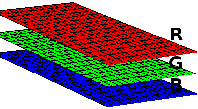
Neste artigo eu explico como ler e criar / escrever imagens de satélite e de informações geográficas no formato .TIF com a biblioteca Gdal em C#.
Importar o Gdal no Visual Studio
Primeiramente, importamos o Gdal para o projeto: no Visual Studio, clique com o botão direito no projeto, vá em "Manage NuGet packages", digite "Gdal" no campo de busca, selecione o Gdal (1.11.1 é a última versão disponível até o momento em que este artigo foi escrito) e instale. Selecione e instale também o Gdal.Native (sem ele o projeto compila mas não executa corretamente). A classe "GdalConfiguration.cs" será criada automaticamente. Ela será usada antes de iniciar o método para conversão.
Para importá-lo em sua classe use:
using OSGeo.GDAL;
Configurar o Gdal
Antes de usar as classes do Gdal, precisamos configurá-lo. Para isso, basta chamar o método ConfigureGdal da classe GdalConfiguration.cs. Você pode chamá-lo, por exemplo, no construtor de sua classe.
public WhiteBalance() {
    GdalConfiguration.ConfigureGdal();
}
Abrindo a imagem
Para abrir uma imagem que já existe use o seguinte comando:
Dataset image = Gdal.Open(imagePath, Access.GA_ReadOnly);
O ideal é usar um bloco de instrução using, para fechar o objeto adequadamente. Para criar uma nova imagem, você deve fornecer seu tamanho, o número de bandas (para RGB são 3) e o tipo de dado de cada pixel (byte, int16, int32, etc).
Dataset outImage = Gdal.GetDriverByName("GTiff").Create(outImagePath, width, height, 3, DataType.GDT_Byte, null)
Acessando cada banda
Uma imagem pode ser vista como uma matriz tridimensional. Cada banda é uma matriz e representa uma cor. Numa imagem RGB existem 3 bandas. Se existir uma camada alfa, por exemplo, ela terá 4 bandas.

Cada banda é acessada com o seguinte código:
Band outRedBand = outImage.GetRasterBand(1);
Para cada banda podemos acessar sua matriz. Neste exemplo, acessamos cada linha da matriz, copiando os dados para um vetor previamente declarado (int[] red) e depois acessamos cada elemento:
for(int h = 0; h < height; h++) {
	int[] red = new int[width];

	redBand.ReadRaster(0, h, width, 1, red, width, 1, 0, 0);

	for(int w = 0; w < width; w++) {
		red[w] = red[w] + 1; // algum processo com cada pixel
	}
}
Escrevendo os dados da imagem
Para escrever os dados na imagem, passamos o vetor de pixels para o método:
outRedBand.WriteRaster(0, h, width, 1, red, width, 1, 0, 0);
Se você quiser ler ou escrever mais dados de uma vez, e não linha a linha, altere os tamanhos e posições nas funções. Por exemplo, para ler e escrever todos os dados da matriz de uma só vez:
int[] red = new int[width * height];
redBand.ReadRaster(0, 0, width, height, red, width, height, 0, 0);
outRedBand.WriteRaster(0, 0, width, height, outRed, width, height, 0, 0);
Ao final, salve os dados de escrita:
outImage.FlushCache();
Ler e escrever imagem com o Gdal
O código completo para ler, modificar e escrever imagens .TIF com o Gdal:
new ReadWrite().ReadAndWriteImage(@"C:\development\input-image.tif", @"C:\development\output-image.tif");
using OSGeo.GDAL;
using System;

namespace Adadev.GdalModule {

    public class ReadWrite {

        public ReadWrite() {
            GdalConfiguration.ConfigureGdal();
        }

        public void ReadAndWriteImage(string imagePath, string outImagePath) {

            using(Dataset image = Gdal.Open(imagePath, Access.GA_ReadOnly)) {

                Band redBand = GetBand(image, ColorInterp.GCI_RedBand);
                Band greenBand = GetBand(image, ColorInterp.GCI_GreenBand);
                Band blueBand = GetBand(image, ColorInterp.GCI_BlueBand);
                Band alphaBand = GetBand(image, ColorInterp.GCI_AlphaBand);

                if(redBand == null || greenBand == null || blueBand == null || alphaBand == null) {
                    throw new NullReferenceException("One or more bands are not available.");
                }

                int width = redBand.XSize;
                int height = redBand.YSize;

                using(Dataset outImage = Gdal.GetDriverByName("GTiff").Create(outImagePath, width, height, 4, redBand.DataType, null)) {
                    // copia a projeção e informações geográficas da imagem
                    double[] geoTransformerData = new double[6];
                    image.GetGeoTransform(geoTransformerData);
                    outImage.SetGeoTransform(geoTransformerData);
                    outImage.SetProjection(image.GetProjection());

                    Band outRedBand = outImage.GetRasterBand(1);
                    Band outGreenBand = outImage.GetRasterBand(2);
                    Band outBlueBand = outImage.GetRasterBand(3);
                    Band outAlphaBand = outImage.GetRasterBand(4);

                    for(int h = 0; h < height; h++) {
                        int[] red = new int[width];
                        int[] green = new int[width];
                        int[] blue = new int[width];
                        int[] alpha = new int[width];
                        // copia cada linha da matriz da imagem para os vetores definidos acima
                        redBand.ReadRaster(0, h, width, 1, red, width, 1, 0, 0);
                        greenBand.ReadRaster(0, h, width, 1, green, width, 1, 0, 0);
                        blueBand.ReadRaster(0, h, width, 1, blue, width, 1, 0, 0);
                        alphaBand.ReadRaster(0, h, width, 1, alpha, width, 1, 0, 0);

                        for(int w = 0; w < width; w++) {
                            red[w] = red[w] + 1; // algum processo com cada pixel
                            green[w] = green[w] + 1;
                            blue[w] = blue[w] + 1;
                            alpha[w] = alpha[w] + 1;
                        }
                        // escrever imagem
                        outRedBand.WriteRaster(0, h, width, 1, red, width, 1, 0, 0);
                        outGreenBand.WriteRaster(0, h, width, 1, green, width, 1, 0, 0);
                        outBlueBand.WriteRaster(0, h, width, 1, blue, width, 1, 0, 0);
                        outAlphaBand.WriteRaster(0, h, width, 1, alpha, width, 1, 0, 0);
                    }
                    outImage.FlushCache();
                }
            }
        }

      /**
       * Retorna a banda para determinada cor (red, green, blue ou alfa)
       * O dataset deve ter 4 bandas
       * */
        public static Band GetBand(Dataset ImageDataSet, ColorInterp colorInterp) {
            if(colorInterp.Equals(ImageDataSet.GetRasterBand(1).GetRasterColorInterpretation())) {
                return ImageDataSet.GetRasterBand(1);
            } else if(colorInterp.Equals(ImageDataSet.GetRasterBand(2).GetRasterColorInterpretation())) {
                return ImageDataSet.GetRasterBand(2);
            } else if(colorInterp.Equals(ImageDataSet.GetRasterBand(3).GetRasterColorInterpretation())) {
                return ImageDataSet.GetRasterBand(3);
            } else {
                return ImageDataSet.GetRasterBand(4);
            }
        }
    }
}
Você pode baixar o código completo no nosso repositório no Github.
Conteúdo relacionado:
Algoritmo Balanço de Branco com Gdal em C#
Converter JSON para shapefile usando Gdal em C#